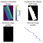
Sandy beaches host a variety of landforms shaped by local hydrodynamics. Among these, beach cusps are particularly notable. They typically form as rhythmic patterns consisting of elevated mounds (horns) and mild gradient embayments along the shore. These cusps not only… Read More
IDENTIFYING BEACH CUSPS FROM HIGH RESOLUTION OPTIC AND SYNTHETIC APERTURE RADAR (SAR) IMAGERY