Carson Clause, an undergraduate researcher at the University of Florida is using coding techniques and statistics to track trends and highlight seabed areas of interest from sonar side scan data. Through data-image processing and statistical methods, data from sonar side scans can be sorted, graphed, and set-up for analysis.
The data currently processed for this project includes side scan sonar surveys from the Piankatank River, VA; Adams Point, NH; Elliot, ME; and the York River, VA. More data will be processed using these methods and the coding techniques will be refined with new data sets.
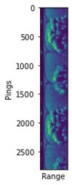
A raw image plot produced from the sonar side scan data collected at the Piankatank River.
The code is currently designed to sort out data points with inconclusive data or high levels of interference. After processing the current data sets with the coding techniques, the goal of the project is to produce a refined image of the sonar side scan data compared to an image generated from the raw data. By removing noise from the data plots, the trends are more visible.
One of the features of the code process is producing images of the side scan data that will color code the number of pings against the distance range for the sonar dataset in order to easily define trends. An example of the produced image can be seen below. It is important to note that this image includes area from the tripod setup of the side scan. The processing code aims to remove this area so only valid data is analyzed.
As the project progresses and new data sets are processed, additional statistical methods will be tested to optimize the codes. Going forward, the produced images will be analyzed to discover trends in sonar side scan data in each location.