
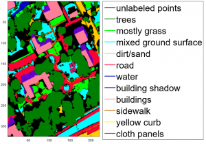
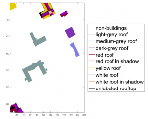
We are excited to announce that we have released a classification label map for the MUUFL Gulfport co-registered hyperspectral and Lidar Campus 1 image . The MUUFL Gulfport data set was collected in November 2010 over the campus of the University of Southern Mississippi-Gulfpark, located in Long Beach, Mississippi. The data contains co-registered hyperspectral and LiDAR data with a ground sample distance of 1m. The classification label map was generated manually using careful review of and manual interaction with the hyperspectral and lidar data sets, aerial imagery over the scene, photographs taken on the ground of the scene and map data.